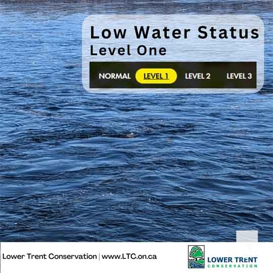

With streamflows across our watershed significantly lower than normal over the past 2 months and into August, Level 1 Low Water (minor drought) conditions are now being experienced across the Lower Trent Conservation watershed region, an area stretching from Grafton to Quinte West, from Lake Ontario to Rice Lake to south of Madoc.
The May to July (3-month) rainfall total recorded by Environment Canada at Trenton was 206 millimeters, which is 91 percent of normal precipitation for this time of year (227 mm), which is inflated due to the unseasonably high rainfall that occurred during May.
The observed precipitation data for June and July data accounts for 38 percent of the normal precipitation for this period.
Monthly streamflow in the majority of our local creeks have dropped below the 70 percent threshold compared to the Lowest Summer Month Average flows, which is a trigger for a Level 1 Low Water Condition.
Drought conditions may continue in the coming weeks, and Conservation Authority staff will continue to monitor precipitation and streamflow to determine if additional actions should be taken.
Droughts can cause many severe impacts on the environment and communities including:
Water shortages for human consumption, industrial, business and agriculture use
Decline of water quality
Increase in wildfires
Increases in insect infestations and plant disease
The general recommendations/actions under the Ontario Low Water Response program manual for Level 1 Low Water condition is a voluntary 10% reduction in water use among all sectors.
Conservation Authority staff will continue to monitor conditions and report new information as it becomes available.
To learn more about Ontario’s Low Water Response program visit our website at www.LTC.on.ca Residents can report any low water observations using the Low Water Reporting Form on our website.

Author: Pete Fisher
Has been a photojournalist for over 30-years and have been honoured to win numerous awards for photography and writing over the years. Best selling author for the book Highway of Heroes - True Patriot Love