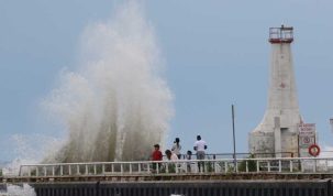

Spring will be here before we know it, enticing people to spend more time outdoors. The warmer temperatures also bring rain and melting snow and ice which can contribute to higher, faster flowing water in watercourses. The Ganaraska Region Conservation Authority (GRCA) is reminding residents of dangers that exist near streams, rivers, ponds and lakes around this time of year and urges people to keep family and pets away from the edge of all waterways. Slippery and unstable stream banks and extremely cold water temperatures can lead to very hazardous conditions close to any body of water.
The increase of rain and melting snow and ice also contribute to flooding. The GRCA maintains a flood forecasting and warning system to reduce risk to life and damage to property by providing local agencies and the public with advanced notice, information and advice so that they can respond to potential flooding and flood emergencies.
A flood is defined as a situation where water levels in a watercourse exceed the channel banks. Flooding across the Province is a fairly common occurrence, as we’ve seen locally in the Municipality of Port Hope. The greatest flood in recent memory hit the area in March of 1980 when the Ganaraska River flowed over its banks as a result of heavy rainfall on a dense snow pack causing major damage to the downtown core.
Should flooding occur in the Ganaraska watershed, the first response is up to property owners who should have an emergency plan in place to minimize damages. If the flood is beyond the property owner’s capability, the next step are municipal emergency plans. Once an emergency has been declared by municipal officials, an emergency plan will be implemented. If you are unfamiliar with your municipality’s emergency plan, the GRCA suggests to look into them and be prepared.
At any time of the year, when there is flooding, GRCA issue three levels of messages for the community to be aware of:
Normal: No flood conditions exist.
Level 1 – Water Safety: High flows, unsafe banks, melting ice or other factors that could be dangerous for recreational users such as anglers, canoeists, hikers, children, pets, etc. Flooding is not expected.
Level 1 – Flood Outlook: Early notice of the potential for flooding based on weather forecasts calling for heavy rain, snow melt, high wind or other conditions that could lead to high runoff, cause ice jams, lakeshore flooding or erosion.
Level 2 – Flood Watch: Flooding is possible in specific watercourses or municipalities. Municipalities, emergency services and individual landowners in flood-prone areas should prepare.
Level 3 – Flood Warning: Flooding is imminent or already occurring in specific water courses or municipalities.
For more information on the GRCA Flood Forecasting and Warning Program, reach out to Mike Smith, Water Resources Technician, at 905.885.8173 or msmith@grca.on.ca.

Author: Pete Fisher
Has been a photojournalist for over 30-years and have been honoured to win numerous awards for photography and writing over the years. Best selling author for the book Highway of Heroes - True Patriot Love