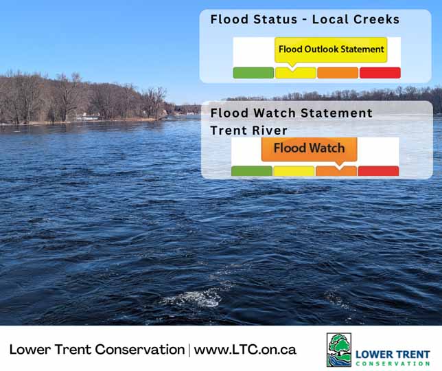

Flood Outlook Statement – Local Creeks
Lower Trent Conservation advises municipalities and the public that a Flood Outlook Statement has been issued for the local creeks within the Lower Trent Watershed region (area stretching from Grafton to Quinte West and from Lake Ontario to Rice Lake and east to Centre Hastings). It is important to note that during this time high water levels, unsafe banks or other factors could be dangerous for recreational users and waterfront landowners. Nuisance flooding for some may occur within low lying and poorly drained areas.
Weather forecasts for the Lower Trent Watershed predict 30-50 mm of rainfall over the course of this week. Additionally, there is also the potential of isolated thunderstorms; in these areas there may be more rain expected. As we head into April the forecast is showing most days to be above freezing temperatures. The above average temperatures forecast, rainfall and snowmelt may lead to increased runoff into local streams.
Water levels along our local creeks and streams are around the average for this time of year; however, increased water levels and stream flow is expected with the forecasted rainfall and increased runoff from snowmelt.
Municipalities and the public should be aware that localized inundation is possible in urban areas where storm drains may not be able to handle the snowmelt and rainfall.
While the potential dangers presented by rivers, small streams and open ditches never cease to exist, they are of particular concern at this time of the year. Water currents are strong and temperatures dangerously cold. Parents and caregivers are advised to keep children and pets away from all waterways. Areas around dams, culverts and bridges should be avoided at all times.
Lower Trent Conservation monitors water levels and weather forecasts closely as part of its flood forecasting and warning program. Daily water level updates are available at www.LTC.on.ca If you have concerns about water levels, please contact Lower Trent Conservation at (613) 394-4829.
This Flood Outlook Statement for local creeks and streams will be in effect until Tuesday April 7, 2026 at 4:00pm.
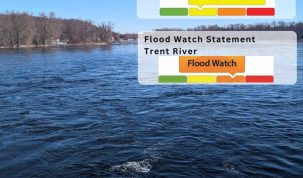
Flood Watch Statement – Trent River
Lower Trent Conservation advises municipalities and the public that a Flood Watch Statement for the Trent River is still in effect. It is important to note that during this time, high water levels, unsafe banks or other factors could be dangerous for recreational users and waterfront landowners. Nuisance or minor flooding of low-lying areas, roads, backyards, basements etc., for some may occur. This Flood Watch Statement is intended as an update to the Flood Watch issued on March 19, 2026.
The Trent River system is still in full spring freshet. Recent temperature fluctuations have slowed snowmelt in the northern reaches of the Trent System. Weather forecasts for the Lower Trent Watershed predict 30-50 mm of rainfall over the course of this week. Additionally, there is also the potential of isolated thunderstorms; in these areas there may be more rain expected. However, as we head into April the forecast is showing most days to be above freezing temperatures. Due to the precipitation received today and the warming temperatures expected to melt the snowpack in the larger Trent River watershed, many areas throughout our watershed and those in the larger watershed system will remain at capacity.
High water levels could cause flooding of driveways, access roads or buildings located in low-lying areas. Residents should ensure their sump pumps are working and secure personal property (boats, docks, etc.) along riverbanks. While the potential dangers presented by rivers, small streams and open ditches never cease to exist, they are of particular concern during these conditions. As a result of the high flows, there is also potential for ice damage where accumulation is still present along the banks of the river. Water currents could be strong and temperatures are cold. Parents and caregivers are advised to keep children and pets away from all waterways. Additionally, areas around dams, culverts and bridges should be avoided at all times.
Lower Trent Conservation monitors water levels and weather forecasts closely as part of its flood forecasting and warning program. Daily water level updates are available at www.LTC.on.ca If you have concerns about water levels, please contact Lower Trent Conservation at (613) 394-4829. Anyone having concerns about water levels on the Trent River can contact Parks Canada (705)-750-4950 or trentsevern@pc.gc.ca.
This Flood Watch Statement for the Trent River will be in effect until Tuesday, April 14, 2026 at 4:00 PM

Author: Pete Fisher
Has been a photojournalist for over 30-years and have been honoured to win numerous awards for photography and writing over the years. Best selling author for the book Highway of Heroes - True Patriot Love