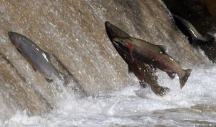
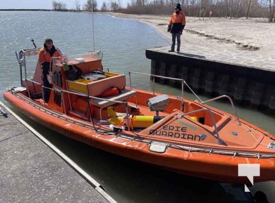
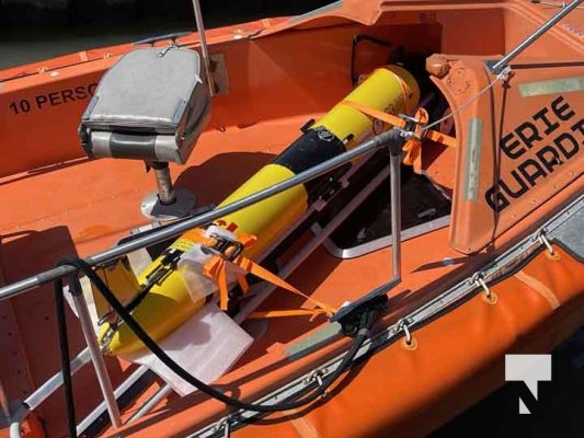
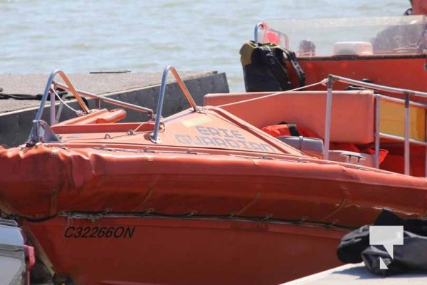
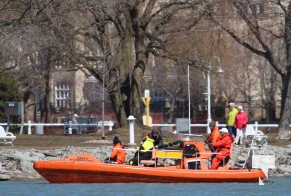
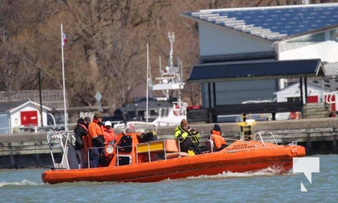
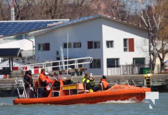
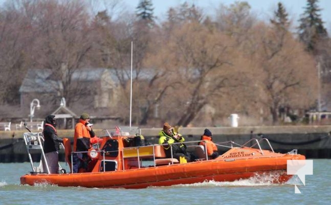

A group of researchers studying the Great Lakes launched from Cobourg on Friday, April 4, 2025 headed for Brighton.
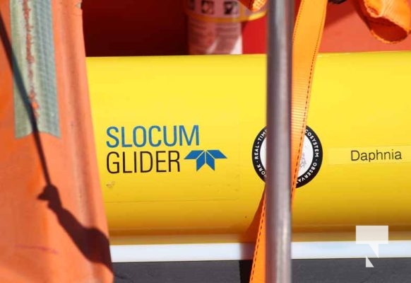
The four researchers boarded the Erie Guardian which is a 25-foot boat that has a crew of two sailed the researchers down to the Brighton area whey they launched a Slocum glider which is a autonomous underwater vehicle (that looks similar to a torpedo) that collects and transmits date for approximately 21 days.
The goal is to improve understanding of water quality and lake ecosystems by supporting research that generates data valuable to management, rehabilitation, and enhancement of these vital resources.
Information below provided by RAEON (Real-Time Aquatic Ecosystem Observation Network
Sensing changes using real-time water monitoring instruments: a guide to the technologies of Real-Time Aquatic Ecosystem Observation Network (RAEON)
The Real-Time Aquatic Ecosystem Observation Network (RAEON) is a networked science initiative that provides infrastructure, staff, and data management to accelerate cutting-edge research on the Great Lakes, supporting freshwater science that contributes to management, decision-making, and conservation.
RAEON is part of the Global Water Futures Observatories (GWFO), a network of nine universities that compose Canada’s largest national university-operated scientific freshwater observation networks, and one of the largest in the world. RAEON has been integrated into GWFO to share tools and expertise; and scale up the operations to make the network pan-Canadian in scope.
We acknowledge that the land in which we work is the ancestral territory of the Three Fires Confederacy of First Nations: comprised of the Ojibwe, the Odawa, and the Potawatomi, who have care for this land since time immemorial. We are grateful to work, learn and live in this area.
RAEON (2025). Sensing changes using real-time water monitoring instruments: a guide to the technologies of Real-Time Aquatic Ecosystem Observation Network (RAEON).
The Great Lakes contain nearly one-fifth of the earth’s freshwater supply and make up one of the largest freshwater systems in the world. In the Anishinaabemowin language, they are called Nayaano-nibiimaang Gichigamiin, often translated as “The Five Freshwater Seas.” Many of us cherish the lakes as sites for recreation and enjoyment, where we swim, boat, walk, and relax by the shores. These vast waters are also much more. They are home to many species and are a source of drinking water for millions of people. And they play a vital role in the economy, particularly for the critical industries of agriculture, manufacturing, and energy production.
Standing by the shore and looking out, it can be easy to assume that these lakes offer us an endless supply of water that will remain unchanged for generations to come. However, the Great Lakes face many overlapping ecological, economic, and political pressures related to a growing human population, increased intensity of industrial and agricultural activity, and a changing global climate. These factors accelerate environmental stressors including invasive species, harmful algal blooms (HABs) driven by rising nutrient concentrations, and pollution from toxic substances like pharmaceuticals, plastics, and contaminants of emerging concern.
Given the ecological, economic, and cultural importance of these indispensable resources, it is more important than ever to understand and protect the health and future of our waters. Understanding these threats and addressing them requires continuous, consistent, and correct data about water quality and the health of the Great Lakes.
The Real-Time Aquatic Ecosystem Observation Network (RAEON) provides the infrastructure, staff, and data management support services to help carry out cutting-edge, integrated, and transformative research that helps keep our Great Lakes healthy.
RAEON’s goals is to improve understanding of water quality and lake ecosystems by supporting research that generates data valuable to management, rehabilitation, and enhancement of these vital resources.
Based at the University of Windsor, and integrated into the Global Water Futures Observatories (GWFO), RAEON provides equipment, information, and capacity that helps scientists, communities, municipalities, and organizations across the country collect real-time data that leads to better decisions about freshwater management.
Why real-time data?
Conventionally, monitoring water quality at offshore locations requires that someone travels out to the site to manually retrieve data from the sensors. Sampling this way creates a time lag between when that data is initially generated and when it is collected by researchers. This is not only costly in terms of time and resources, but can lead to patchy, inconsistent, and fragmented snapshots of freshwater health.
In contrast, the RAEON network collects and broadcasts data in real-time. Real-time data refers to information that can be shared immediately as it is being collected. At key strategic locations throughout the Great Lakes, RAEON deploys different automated sensors that gather information about a range of freshwater indicators. Each of these indicators tell us a different piece of the story of what is going on in waters. The real-time aspect of these sensors wirelessly transmits the information to open data platforms, where members of the public, scientists, and decision-makers can see what the water quality indicators are telling us.
This real-time freshwater data helps us in many ways. We can use it to gather more data at finer scales so we can better understand long-term trends in water quality. It also enables faster detection of problems and responses to emergencies. Real-time data generates critical information, sharing it with the organizations and decision-makers in charge of managing our environment. Water utilities, government employees, scientists, and the public can all benefit from access to the kinds of real-time data that RAEON provides, helping us all manage our water resources better, and conserve them for present and future generations.
The vastness of the Great Lakes may be impressive, but their sheer size creates challenges for the scientists who study them. Scientists typically sample lakes by heading out into the water on boats, manually collecting samples that they then mail to laboratories for analysis. In bodies of water as deep and expansive as these, manual sampling is not always practical or cost-effective.
Central surface buoys help address these challenges by enabling continuous, real-time data collection.
The buoys are floating observing stations that are built for ocean use and can withstand rough conditions. These robust stations are anchored to the lake bottom and are equipped with sensors that continuously monitor key water quality parameters such as temperature, salinity, pH, turbidity, and dissolved oxygen levels. Additionally, they also can measure physical conditions like wave height, wind speed, and air pressure.
Central surface buoys can be strategically placed in remote or difficult-to-access areas that would otherwise be tough to reach. With multiple buoys deployed, researchers in the RAEON network can generate data simultaneously from different locations, capturing seasonal changes and long-term trends.
By continuously making observations at regular intervals over a timespan of months or years, these buoys provide crucial information that captures the changing dynamics of the lakes, water quality, and ecosystem health.
In 2019, RAEON acquired its first three NexSens CB450 buoys. Powered by solar panels, each buoy has an internal compartment containing two separate data loggers. These data loggers each communicate with a different set of sensors, equipped to monitor water quality, water currents, waves, and weather conditions.
The sensors can be placed on separate hazard buoys, which can be located up to 1 kilometre away from the main station. The sensors are suspended underwater to measure water quality indicators such as dissolved oxygen, chlorophyl-A, turbidity, and blue-green algae. The data loggers store this information, and the buoys broadcast it in real-time. RAEON’s CB450 buoys are also outfitted with weather stations that can collect information about the conditions above the waters, including air temperature, humidity, wind speed, wind direction, air temperature, and wave height. The buoys are outfitted with another type of sensor, acoustic doppler current profilers (ADCP), which measure the speed and directions of water currents, as well as thermistor strings, that drop into the water to profile the water temperature at different intervals.
· What RAEON has: NexSens Central Surface Buoys from Limnotech, in three sizes.
· How it works: The buoys are floating observation stations that are moored in the lake. Powered by solar panels, they have internal data loggers that store information the sensors collect. The sensors can be attached to the buoy itself, or up to 1 km away on separate hazard buoys.
· What does it tell us? All RAEON buoys can be connected to sensors that measure various water quality indicators, including dissolved oxygen, phycocyanin, CDOM, chlorophyll, salinity, turbidity, water level.
Some of the buoys are also outfitted with weather stations for atmospheric monitoring equipment to collect data on wind speed, wind gust, wind direction, wave height, wave period, wave direction, current speed, current direction, air temp, air pressure, and water temperature at different intervals.
· Real-world examples:
o Gathering and developing early-warning models to alert the Union Water Supply System about the potential of harmful algal blooms and to inform decision-making and rapid response.
o Providing real-time data on wind speed, currents, and wave direction to the community of LaSalle, Ontario, after the 2019 floods.
In 2020, after the flooding of Lasalle, Ontario, RAEON purchased two smaller NexSens CB150 buoys to be placed in the Detroit River. With these buoys, RAEON was able to provide the community with real-time data on currents, wave direction, and wind speed to help inform the community about the potential for future flooding events.
In the Great Lakes, where nutrient loading and algae are ongoing concerns, real-time monitoring is essential for early intervention. In 2020, RAEON was approached by the Union Water Supply System (UWSS), a water utility that provides drinking water to 66,000 residents in the municipalities of Essex, Kingsville, Lakeshore, and Leamington, as well as many greenhouses in in Southwestern Ontario. In collaboration with UWSS, RAEON purchased two additional medium-sized CB450 buoys. These buoys have water quality sensors and weather stations capable of measuring wind direction, wind speed, humidity, and air temperature. With these buoys, RAEON data is helping to develop early warning models that alert the UWSS of the development of HABs, helping them make informed decisions and plan for rapid responses.
Central surface buoys form the pillar of RAEON’s network of sensing instruments. By detecting changes in water temperature or nutrient levels, these buoys can provide early warnings of potential HABs outbreaks, helping authorities make better decisions. They can be deployed in offshore locations that are difficult to access – and provide continuous, consistent real-time monitoring of chemical, physical, and biological conditions – which supports effective management and protects the ecological and economic health of the Great Lakes.
ACOUSTIC TELEMETRY INSTRUMENTS
To get a full picture of the health of the waters, we also need to understand the living organisms within them. Acoustic telemetry (AT) is an advanced technology that biologists use to study the movements and behaviour of aquatic animals, particularly fish. At the most basic level, AT can be described as the measurement of sound (acoustic) from a distance (telemetry). Acoustic telemetry systems involve two main components: transmitters and receivers. The transmitters are electronic tags that are attached to fish, and the receivers are small data loggers which are placed throughout the waters. The transmitters emit regular pulses of sound into the surrounding waters at intervals. These sounds “ping” off the receivers, which pick up the transmitters’ signals from up to 1 km away, revealing the location of tagged fish and providing a record of their movements.
AT provides fine-scale locational data that helps monitor fish populations, migration patterns, habitat use, and survival. Traditionally, ecologists would study fish movements using the “mark-recapture” method: catching and tagging fish, releasing them, and then hoping to re-catch the same individual later.
This approach is not effective in waters as big and deep as the Great Lakes, where fish can travel great distances. AT addresses this issue by tracking fish movements with high precision and over extended periods, even in the deep, murky waters where finding fish can be difficult.
0. What RAEON has: Acoustic receivers from Vemco, transmitters (tags implanted in fish), heartrate and temperature loggers, and accelerometers.
0. How it works: The AT transmitters broadcast a signal that the receiver picks up, revealing fish location. Loggers can record heart rate (via ECG sensors) and temperature, while accelerometers can quantify the tail beats of fish. <
0. What does it tell us? Acoustic telemetry tells us where, how, and when fish are moving, which can give insights into the impacts of dams, fishing, boating, and other human activities. AT can also be used to assess the health of important native species like lake trout, and track the movement of invasive species like sea lamprey.
By deploying receivers across the Great Lakes, scientists have created a network of monitoring stations that tracks fish movements and behaviour in real-time. RAEON’s AT instruments are integrated within the bi-national Great Lakes Acoustic Telemetry Observation System (GLATOS). GLATOS is a highly collaborative network of Great Lakes researchers who use AT to study fish behaviour, migration routes, seasonal movements, feeding patterns, and reactions to environmental changes. RAEON’s buoys also improve the spatial resolution of the GLATOS map by offering reliable offshore “parking spots” for AT receivers.
The AT instruments in the GLATOS network help researchers understand how fish movements and behaviour are affected by human activities, including commercial fishing, dams, power generation, and boating. By studying the movements of fish in such fine detail, AT research supports habitat protection, stocking and management strategies, and resource use.
Managing the vital ecological and economic resources of the Great Lakes fisheries requires a consistent source of accurate data about fish populations, movement, behaviour, and survival. With AT, scientists can monitor native species like salmon, lake trout, lake sturgeon, and American eel, which can travel great distances at different life cycle stages as they search for food, spawning sites, or suitable habitats.
This data can be shared with fisheries management authorities, informing decisions about how to best protect the $70-million a year salmonoid fishing industry, for example.
For species at risk, such as lake sturgeon, AT generates important information about spawning behaviors, population dynamics, and the effectiveness of restoration efforts. Using AT, scientists can identify the best sites for habitat protection or restoration, helping ensure the sustainable management of these valuable species. For example, by tracking the migration routes of salmon and understanding when and where they spawn, managers can assess how to minimize interference with spawning cycles.
The Great Lakes have also been significantly affected by invasive species, including sea lamprey, grass carp, and round goby, which enter the waterways by canals or from ocean liners discharging their ballast waters. In total, regional management efforts to combat the spread of sea lamprey cost around $26 million per year. By tagging lamprey, it is possible to track their movements, gain insights into their behaviour, and better understand their interactions with native fish populations. This information can guide management efforts, informing the placement of traps, barriers, or the application of “lampricide” compounds.
In addition, AT data helps inform decisions about stocking programs, such as whether hatchery-reared fish are successfully integrating into wild populations and using key habitats. In 2022-2024, RAEON researchers used AT instruments to study the success rate of stocking programs for bloater, a native fish that was being reintroduced into the Great Lakes.
By providing researchers with fine scale real-time data about fish movements, behaviour, and habitat use, AT instruments are key components of RAEON’s sensor network. Scientists are now tracking tagged fish across a gridded network of receivers in real-time, answering key questions about migratory patterns, habitat preferences, and the effects of both natural and human-induced changes on aquatic ecosystems. This research plays a key role in fisheries management, invasive species detection, and conservation, helping to support the long-term sustainability of the Great Lakes’ diverse and economically important fish populations.
SLOCUM GLIDERS
Teledyne Slocum gliders are autonomous underwater vehicles (AUVs), designed to traverse large waterbodies and collect data without the need for a human pilot. The gliders are buoyancy-driven, meaning that they move by varying their internal buoyancy in relation to the water column in a rise-and-fall “sawtooth” pattern. This movement makes it possible for them to travel far and wide without the need for engines, propellers, or thrusters.
Because these gliders—named after Joshua Slocum, the first person to sail around the world on a solo mission—are designed to be used in oceans, deploying them in the Great Lakes presents both opportunities and challenges. Unlike boats or ships, which require fuel and people, Slocum gliders run on rechargeable batteries and can stay in the water for weeks or even months at a time. This unique capability make it possible for them to go on extended autonomous missions to continuously collect high-resolution data. In addition, gliders are highly mobile and collect data across different locations, providing both temporal and spatial data. In contrast, buoys collect data continuously from one location over time. Using them in the Great Lakes, however, means encountering difficulties such as a shallower depths, increased recreational boat traffic, and the need to retrieve them before winter sets in and ice begins to form on the waters.
· What RAEON has: Three G3 Slocum Gliders manufactured Teledyne Technologies Inc.
· How it works: The gliders are autonomous underwater vehicles which move up, down, and across the waters on extended missions over long periods.
· What does it tell us? The gliders collect spatial and temporal data related to parameters such as conductivity, temperature, and depth (CTD), phycocyanin, fluorescence, chlorophyll, and dissolved oxygen sensors.
· Real-world examples:
o In 2020, working with the National Oceanic and Atmospheric Administration and the University of Michigan Cooperative Institute for Great Lakes Research, gliders were sent out on their first mission to gather data on hypoxia in Lake Erie.
o In 2021, RAEON collaborated with the Ohio Department of Natural Resources using data from the gliders to help them determine when to do their fish trawl surveys.
o RAEON has also worked with the Canadian Department of Fisheries and Oceans in Lake Ontario to continuously collect high-resolution spatial and temporal data to better understand key lake processes and their influence on the lower food web. Phytoplankton, zooplankton and small invertebrates form the base of the food web and supports the $70 million per year salmonoid fishing industry.
This autonomous and long-distance capabilities of Slocum gliders make them particularly valuable for monitoring Great Lakes water quality. Sending a glider out on an extended mission means that data can be collected 24 hours a day, providing a much richer dataset compared to traditional boat-based sampling methods. Additionally, the gliders can reach areas of the lake that would otherwise be inaccessible, like remote, deep waters far offshore; areas affected by storms; or sensitive locations where boats might be restricted.
Slocum gliders are equipped with sensors that gather high-resolution data on several important water quality and physical parameters. These sensors measure conductivity, temperature, and depth (CTD, phycocyanin, fluorescence, chlorophyll and dissolved oxygen, which are critical for assessing the health of the water and the ecosystems that depend on it. As the gliders move up and down through different depths of the water column, they capture detailed information about the stratification of water conditions, such as temperature gradients, oxygen levels, and distribution of nutrients.
In the Great Lakes, where water conditions can vary dramatically from the surface to the deeper layers, vertical profiling is necessary to understand water quality at different depths. For example, understanding how nutrients like phosphorus and nitrogen are distributed throughout the water column can help researchers track potential sources of pollution or predict HABs. Slocum gliders can detect these variations in real time, adding an important dimension to RAEON’s early warning system. If a glider detects abnormal changes in temperature or dissolved oxygen levels—both key indicators of potential HABs or the onset of hypoxia (low oxygen)—scientists can quickly respond and investigate further. Like the sensor buoys and AT receivers, Slocum gliders provide real-time data, transmitting live to an open data web portal where it can be viewed and access by scientists, managers, and the public.
Despite being designed for oceans, researchers can exploit the unique capabilities of Slocum gliders for monitoring freshwater in the Great Lakes. Their ability to operate autonomously for extended periods, gather high-resolution data through vertical profiling, and transmit real-time information present key advantages without the logistical challenges and expense of deploying traditional research vessels. The data collected from RAEON’s Slocum gliders help build better models for predicting change. These data also contribute to improved management, as they are used by local water utilities and commercial fisheries to understand potential upstream impacts of what is happening within the lower food web. As part of RAEON’s broader suite of sensing instruments, Slocum gliders support early detection of environmental issues, long-term ecological research, and informed decision-making by providing scientists and policymakers with the data needed to safeguard these important ecosystems for vital industries and future generations.
MULTI-PARAMETER WATER QUALITY SONDES
Stormwater runoff, recreational activities, and discharges from agriculture and other industries affect surface water quality. Multi-parameter sondes can provide critical early warnings about pollution and nutrient imbalances near shorelines. Researchers can use sondes to collect data about a range of different water quality indicators simultaneously. Whereas buoys and telemetry receivers are stationary instruments deployed in a single location to collect data across time, and Slocum gliders are sent off on longer-term missions, surface water quality sondes present an adaptable approach for monitoring multiple conditions across different locations at different times. RAEON’s sondes can be deployed on buoys to monitor water conditions 24/7. They can also be used in conventional approaches to sampling, where scientists head out into the waters by boat and dip the sondes into the water at designated sampling points.
RAEON’s sondes are equipped with a variety of sensors that can measure a broad range of water quality parameters, including temperature, pH, depth, turbidity, dissolved oxygen, chlorophyll-a, CO2, and coloured dissolved organic matter (CDOM) levels. These parameters are particularly important in shallow, near-shore environments where water conditions can fluctuate rapidly due to changes in weather, human activities, and biological processes.
0. What RAEON has: Surface sondes and deep water sondes manufactured by RBR.
0. How it works: Sondes can sample all parameters at 8Hz, run on AA battery, and have Wi-Fi. Sondes can be deployed on buoys, or over the side of boats.
0. What does it tell us? Sondes measure temperature, depth, CDOM, chlorophyll-a, CO2, fluorescence, dissolved oxygen, pH, phycocyanin, turbidity.
RAEON has two types of sondes: for surface water and for deep water.
Surface-water sondes can be used for long-term studies of changes in near-shore conditions, as well as more immediate monitoring in the wake of high-risk events. They can detect problems like spikes in turbidity from stormwater runoff, or sudden drops in oxygen levels that might indicate pollution events or other causes of biological stress.
Deep-water sondes are designed to gather data at much greater depths, making them great tools for monitoring deeper, cold areas of the Great Lakes. The high-resolution data gathered by deep-water sondes can tell us a lot about temperature stratification, a process where warmer water sits on top of colder, denser water. These sensors help us see how the different layers of water interact with each other over time, collecting essential information for understanding seasonal turnover, oxygen dynamics and hypoxia, nutrient cycling, and the effects of climate change—all of which impact the health of the Great Lakes fish stocks.
By combining data from both types of sondes, researchers can understand changes at the water’s surface from agricultural nutrient runoff and how it interacts with deeper layers to influence overall lake health.
These sondes are also the most mobile, transportable, and immediately deployable instruments in RAEON’s network, which means that they can be deployed quickly if an event occurs that could affect water quality.
SUBMERSIBLE NITRATE ANALYZERS
The Seabird Scientific SUNA V2 (Submersible Nitrate Analyzer), or SUNA, provides continuous, real-time measurements of nitrate concentrations in water. In Lake Erie, where nutrient loading from the nearby agriculture industry is a big concern, it is important to monitor concentrations of nitrogen compounds like nitrates. Entering waterways from farm runoff, wastewater and sewage, and discharges from industry, nitrates are a key driver of eutrophication, the process whereby a waterbody becomes overly enriched with nutrients. This over-enrichment stimulates growth of plants and algae, which can have dangerous impacts on water quality and lead to HABs. In extreme cases, eutrophication can kill fish, harm water treatment plants, and make lake water unsafe for drinking or recreation.
SUNAs are submersible sensors that measure nitrates continuously in real-time. Like the sondes and the surface buoy sensors, they are placed directly in the water, passively collecting data without the need for regular water sample collection. They can be deployed on RAEON’s buoys and provide autonomous, continuous monitoring for long periods.
Traditionally, nitrate sampling involves manually collecting a sample and mailing it to a laboratory for analysis. Since nitrates are biological compounds, samples collected using this approach can easily be contaminated during data collection, handling, or transportation. As in situ instruments that collect data from within the waters, SUNAs significantly reduce the risk of contamination from physically handling sensors or samples. By taking measurements in-situ, they generate data that is more accurate and more representative of the conditions than would be possible with manual, point-sampling approaches.
Additionally, the continuous and real-time dimension of SUNAs means that scientists and researchers can track changes in nitrate concentrations as they happen. This latter approach is better suited to the Great Lakes, where nutrient concentrations can fluctuate rapidly in response to seasonal changes, weather events, and human activities.
0. What RAEON has: Seabird scientific SUNA V2
0. How it works: Measures nitrate at 5mm pathlength with integrated hydro-wiper RS-232 and SDI-12 communications, internal logging/USB communications, and submersible battery pack.
0. What does it tell us?
0. Real-world examples:
This real-time data is especially important for understanding the dynamics of nutrient pollution. By continuously monitoring nitrate concentrations, SUNAs help researchers and environmental managers track pollution events, enabling more timely and targeted interventions. For instance, if a spike in nitrates is detected, then managers can make changes to water treatment processes or put processes in place to reduce nutrient inputs. Continuous monitoring also helps managers assess whether efforts to control or mitigate nutrients have been effective by looking at how changes to agricultural practices or wastewater treatment processes affected nitrate concentrations.
eDNA COLLECTORS
Sensors are incredible tools that provide accurate data about chemical and physical conditions that influence water quality, but what about the living organisms in the waters? Researchers can use AT transmitters to tag and track larger animals, like fish; this approach is not feasible, however, for tiny, microscopic plants and animals.
Environmental DNA (eDNA) analysis is a state-of-the-art approach that is revolutionizing how scientists study ecosystems. As animals move through the environment, they leave traces of their presence through skin, fur, carcasses, or feces. These traces contain genetic material that provides a signature for each species. By collecting samples from the environment, scientists can use eDNA metabarcoding technologies to detect what species have been living in or moving through the area (a bit like the television show “CSI,” but for environmental monitoring). Unlike traditional methods that rely on visually identifying, tagging, or physically collecting individual specimens, eDNA sampling allows for the simultaneous detection of a broad range of species, including cryptic and elusive ones that are difficult to find.
RAEON’s network includes ROMOR Ocean Solution Phytoplankton Samplers, which are specialized eDNA collectors that use water samples to analyze DNA from phytoplankton, microorganisms, and other aquatic organisms present in the water. The samplers can be deployed on boats, buoys, and other stationary platforms and can collect samples at varying depths. As a result, researchers can gather biological data at various remote and hard-to-reach spots on without the logistical challenges of traditional sampling methods. This efficiency also allows for more frequent data collection, creating detailed, real-time information about the presence and abundance of aquatic species. [case study?]
Phytoplankton form the base of the food web in the Great Lakes, releasing oxygen and serving as primary producers. They capture sunlight and convert it into forms that other living organisms can use as food, making them the essential backbone for the health of the entire ecosystem, as well as the economy.
Monitoring phytoplankton is essential for understanding the overall health of the lakes, as shifts in their composition can signal changes in water quality, such as nutrient loading, algal blooms, or the effects of climate change.
What RAEON has: ROMOR Ocean Solutions Phytoplankton samplers
0. How it works: Automated particulate samplers. Sample 24 individual water samples at a time through 47 mm filters.
0. What does it tell us?
0. Real-world examples:
Not all algae are the same. There are thousands of algae species, and most are beneficial. Only a few species can negatively affect humans or produce harmful toxins. Unfortunately, under certain conditions, these species can proliferate quickly and cause major problems.
Using eDNA samplers in the Great Lakes can help ensure early detection of HABs. They can provide alert scientists or managers when non-native or toxic algae species, like Cyanobacteria (blue-green algae), are present in the water and which can produce a range of toxins known as cyanotoxins that can cause harmful health effects in humans and animals. Early detection of HABs is essential for taking immediate action to protect public health by issuing advisories or switching the source of the water supply from lakes to reservoirs.
Beyond algae, eDNA analysis can also provide information on other potentially problematic organisms that may be present. For example, invasive species such as zebra and quagga mussels, sea lamprey, and certain aquatic plants can disrupt food webs, outcompete native species, and create major changes to the ecosystem. Monitoring these species is critical for maintaining the ecological balance of the lakes. eDNA sampling can detect these species even when they are only present at very low concentrations or before they are visible. This early detection can give management agencies the lead time needed to implement contingency plans before a situation becomes unmanageable.
Sampling eDNA offers several advantages over traditional approaches to freshwater biological monitoring. First, this method is passive and non-invasive and does not require physical handling or trapping of animals, helping to protect sensitive or endangered species. Second, eDNA analysis provides higher-resolution data for earlier and more immediate detection of toxic, nuisance, or invasive species.
In combination with the sensing instruments that track water chemistry, eDNA samplers add an important dimension to RAEON equipment, helping to assess biological indicators of water quality, while monitoring biodiversity, detecting the presence of invasive species, and providing early warning signs for toxic algae and HABs.
WHERE DOES THE DATA GO?
The data collected by RAEON sensing instruments are used to inform decision-making at various levels—from helping scientists better understand the core patterns and processes that inform lake health, to municipalities and water utilities managing the sources of drinking water for millions of people, to the industries that depend on the waters and the living web within them. Thanks to new digital platforms that store, manage, and visualize water quality data, it has never been easier to find and view this.
The information gathered through the sensing network gets uploaded to open data portals, where it can be freely and easily accessed by anyone. RAEON data is shared via the Great Lakes Observing System’s (GLOS — a binational, nonprofit) Seagull open-data platform. Seagull allows people to view live lake conditions and access high-quality, up-to-date data from buoys and sensors. This data helps support Great Lakes science, policy, and management, while also helping members of the public make informed decision about swimming, fishing, boating, and other activities. Seagull visualizes water quality data through an interactive map and provides real-time and historical data about water temperature, water current, wind speed, and the tracking of phytoplankton species that are risks for HABs.
In addition to Seagull, platforms like the Great Lakes Datastream and Water Rangers also provide water quality data from sources ranging from government agencies to community-based participatory science groups.
The Great Lakes Datastream is an open access platform that aggregates water quality data from a variety of sources, including community-based water monitoring groups, government agencies, conservation organizations, and other scientists. The Great Lakes Datastream is one of five regional “hubs” on the Datastream platform, alongside Pacific Datastream, The Mackenzie Datastream, The Lake Winnipeg Datastream, and the Atlantic Datastream. On the platform, users can view data on various indicators, including temperature, pH, and dissolved oxygen. Data is presented on interactive maps, where users can zoom in on different regions and click to view the observations associated with a location of interest.
For each observation, Datastream visualizes the data, provides summary statistics, and offers a helpful plain-language “science explainer” with information about the indicator, how it is measured, why it matters, and what other factors it is related to.
Water Rangers is a participatory science platform where volunteer groups collect and share water quality data from their local streams, lakes, and rivers. Community-based water monitoring groups (CBWM) can use this platform to upload the data that they collect using Water Rangers test kits. There, users can view maps of water sampling locations, filter results by parameter or date, and explore trends in water quality.
The Water Rangers platform makes it easy to find information on whether a group has been sampling a local stream or river. They also encourage community member involvement, or to add local waterbodies that are missing.
GETTING INVOLVED
RAEON’s sensing instruments are key components of a broader network that tracks early warning signs of ecological problems in the Great Lakes region. But these sensors only tell us part of the picture.
Understanding what is happening in the waters and being prepared to take action is best tackled with an “all hands on deck” approach.
One of the best ways to get involved is through participating in community science. Volunteer community scientists collect vital information about water quality, invasive species, and environmental health. Since they usually live near where they sample, community scientists are more motivated to turn data into action and advocate for tangible outcomes that help conserve and improve their environments. When empowered to take ownership over their local freshwater ecosystems, community scientists can engage the broader public and raise awareness about what they are finding. There are many examples of success stories that demonstrate how community scientists can help turn data into action. When residents, local businesses, and recreational users understand the environmental issues affecting their waterbodies, they can be motivated to adopt more sustainable practices, such as reducing fertilizer use, planting native plants along shorelines, replacing aging septic systems, or participating in shoreline cleanup efforts.
All around the Great Lakes region, community groups are engaging in monitoring, stewardship, conservation, and action. RAEON works alongside The Lake Erie Volunteer Science Network (LEVSN), a regional resource organized by the Cleveland Water Alliance, that helps coordinate and community science programs around Lake Erie on both sides of the border. LEVSN helps groups collaborate, standardize their efforts, and share knowledge about best practices for monitoring.
In addition to creating a data portal, the Canadian non-profit group Water Rangers makes and sells easy-to-use water test kits to help grow community science across the country. With Freshwater Alliance, Water Rangers has supported the Lake Erie Guardians water monitoring program to increase the scale of water sampling across the region. Regional environment agencies also routinely offer opportunities to get involved with volunteer water monitoring. In Ontario, Conservation Authorities often coordinate stream sampling opportunities to teach people how to monitor their watersheds.
Many efforts are already underway to engage the public about freshwater data. Knowing how to access, understand, interpret, and collect information about water quality can be an important first step in advocating for lasting change. This engagement can inspire advocacy around key issues that threaten the health of the Great Lakes and help foster productive collaborations between scientists and community members who are united in a commitment to conserving and protecting these vital resources. When government agencies and research scientists notice community involvement and mobilization around environmental issues, they may be more likely to step in and support long-term responses to address those issues.

Author: Pete Fisher
Has been a photojournalist for over 30-years and have been honoured to win numerous awards for photography and writing over the years. Best selling author for the book Highway of Heroes - True Patriot Love